The flight plan contains many strange annotations. According to the IACO report almost all these annotations were done by Korean airlines staff after the incident. This is strange as one would think Korean airlines would keep the original as signed by Captain Chun to aid any investigation and do any calculations on a copy. It is also curious how Korean airlines knew about various aspects of the flight before any of the authorities.
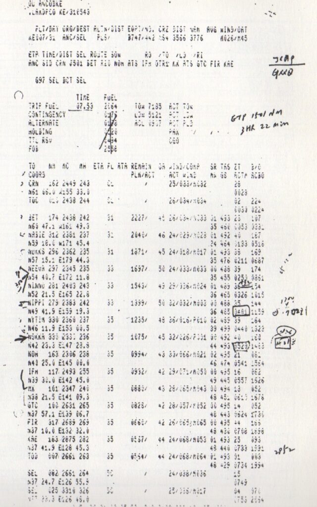
The top annotation clearly appears to be JCMP GXXO but Korean Air states this is JCA9 GXXO and were specific route identifiers for a teletype request for a computer flight plan; both had been added by the flight dispatcher. GXXO could also be G Lambda Lambda O. JCMP also stands for Military Japanese Command Post.
The automated fuel calculations are all crossed out which matches the Captains fuel calculations. However this is further muddied with the IACO 1993 report stating they were given a separate Flight plan that doesn’t have the fuel calculations crossed out.
Next annotation appears to be GTP 1501 NM, 3Hr 22min but most investigators believe this to be ETP and interpret this as Equal Time Point or the place where in the event of an emergency it is quicker to turn back or go on. However, this is not the equal time point but corresponds exactly to where KAL007 supposedly entered Soviet airspace so is more likely Estimated Time Point. The distance NEEVA to Anchorage is 1501 NM but the distance NEEVA to Seoul is is much further and the distance to the closest civilian airport is Sapporo is only about 1079NM
Next to the waypoint NEEVA there is what appears to be an 18deg chevron indicating a turn with 250 (possibly NM) inside the chevron. On the right there is c/- 12nm (the 12nm is very hard to read and could be anything)
On the right at waypoint NINNOI there is +32 with double underline
Waypoint NIPPI is high lighted with a square around the time and some curious annotations to the right including a small circle with an arc around it, 13:50 4deg 702Z1
Way point NOKKA has a large arrow next to it as this is where the incident occurred, the arrival time highlighed then what appears the actual incident time 18:26 in a circle and plus hard to read (could be M31) in a square box followed by 3 horizontal lines
More curious (if these annotations were indeed done by Korean Airlines after the event) is the highlighting of the route between IFM and MX and then a light line to GTC (which is Niigata). If the flight had terminated at NOKKA why continue to make annotations.
Finally there is 2852